

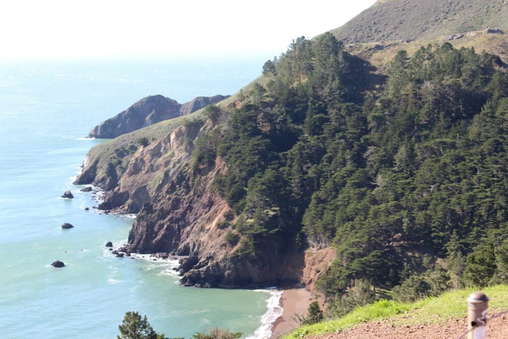
This is a short hiking guide for San Francisco and the closest hills across the bridge. It lists only trails we could check on an official page, with the distance, surface and whether dogs are allowed. Distances and rules were read on November 3, 2026. Trails and closures change, so check the NPS alerts before you go. For a longer outing built around the Headlands, see the Marin Headlands day trip.
Hikes at a Glance
| Hike | Distance | Surface and rules | Where |
|---|---|---|---|
| Lands End Coastal Trail | 1.7 miles one way | Compacted aggregate and pavement, some stairs | In San Francisco |
| Mile Rock Trail (Lands End side trail) | 0.30 miles round trip | Native and sand; 165 feet of descent | In San Francisco |
| Batteries Loop | 0.5 mile, about 1 hour, 60 feet of climbing | Compacted natural material; leashed dogs permitted | Marin Headlands |
| Coastal Trail to Battery Townsley | 0.7 miles from the Rodeo Beach trailhead; allow at least 45 minutes | Strenuous, per the NPS | Marin Headlands |
| Tennessee Valley Trail | 1.75 miles, about 1 hour | Asphalt for about ¾ mile, then compacted natural material; no dogs | Marin Headlands |
| Golden Gate Bridge walk | About 1.7 miles across | East sidewalk; gate hours apply | Bridge |
Not confirmed: Elevation gain for Lands End, Battery Townsley and Tennessee Valley. The NPS pages we read give slope percentages for some trails but no total climb for these. Whether dogs are allowed at Lands End and at Battery Townsley is also not confirmed here.
In the City: Lands End
Lands End is the best trail inside San Francisco. The Coastal Trail is 1.7 miles one way, with stairs in places, a steepest grade of 18.5 percent and the Merrie Way lot as the main trailhead. The full details, the Lookout visitor center and the Mile Rock side trail are in the Lands End Trail guide.
Across the Bridge: Marin Headlands
Batteries Loop
The easiest gun-battery walk. It starts at the Battery Alexander parking area and passes batteries Smith-Guthrie, O’Rorke and Alexander on a former jeep road. The NPS lists it as 0.5 mile and about an hour, with views of the Pacific and, on clear days, the Farallones about 30 miles away. Leashed dogs are allowed. There is no drinking water on the trail.
Rodeo Beach to Battery Townsley
Follow the Coastal Trail from the Rodeo Beach trailhead for 0.7 miles to Battery Townsley, which the NPS calls strenuous. It houses two 16-inch guns completed in 1940 and is open for tours on set days. See the day trip for the battery’s history.
Not confirmed: A longer Rodeo Beach loop of about 5.3 miles with roughly 1,076 feet of climbing appears on a third-party hiking site. We have not checked it against an NPS map.
Tennessee Valley Trail
A 1.75-mile trail to Tennessee Beach, about an hour, paved for about three-quarters of a mile and then compacted dirt. The NPS says dogs are not allowed. Rangers close the beach and trail when the pond water is high, because a sudden dam failure could be dangerous downstream. The NPS says the valley fills with wildflowers in spring.
Not confirmed: Whether the 1.75 miles is one way or round trip. The NPS page does not say; other sites call it about 1.7 to 1.8 miles one way.
Viewpoints Worth a Short Walk
The NPS names Battery Spencer and Hawk Hill among the Headlands’ scenic vistas, and Battery Wallace has a picnic area with tables and grills but no water. We have not confirmed trail lengths or parking for these. Start from the NPS Marin Headlands page.
The Bridge Walk
Walking the Golden Gate Bridge is a hike in its own right: about 1.7 miles across, east sidewalk only, with gates that close at 9 pm in summer and 6:30 pm in winter. Full facts, parking and what not to bring are in the day trip guide.
Safety and Etiquette
- Poison oak: the NPS flags it on its Headlands trail pages. Stay on the trail.
- Cliffs: the NPS says bluff cliffs can be unstable. Keep behind railings and signs.
- Weather: dress in layers, because coastal weather changes quickly.
- Water: none is available on the Batteries Loop or the Tennessee Valley trail.
- Wildlife: keep distance and never feed animals. See San Francisco Wildlife.
- Cell service: expect gaps in the Headlands.
What We Could Not Confirm
- Elevation gain on most trails here.
- Dog rules at Lands End and Battery Townsley.
- Parking at Rodeo Beach, Battery Spencer and Morning Sun.
- The Rodeo Beach loop length and climb.
More to Explore
More Guides
Point Reyes Day Trip From San Francisco: Elephant Seals and Fees
Point Reyes National Seashore is free to enter and open every day. When to see elephant seals, how to get to Chimney…
Read the guide →Marin Headlands Day Trip: Golden Gate Bridge Walk, Hikes and Gun Batteries
A day in the Marin Headlands: walk the Golden Gate Bridge, hike the coastal trails and see Battery Townsley, the Batteries Loop…
Read the guide →San Francisco Wildflowers and Plants: Where and When to See Them
Native coastal scrub and dune plants, California poppies, lupine, redwoods, and the Botanical Garden and Conservatory of Flowers in San Francisco, from…
Read the guide →Questions People Ask About Hiking Near San Francisco: Lands End, Marin Headlands and the Bridge
What is the best hike near San Francisco?
Inside the city, the Lands End Coastal Trail is 1.7 miles one way with ocean and bridge views. Across the Golden Gate Bridge, the Marin Headlands have shorter loops past old gun batteries.
Are dogs allowed on Marin Headlands trails?
The NPS says dogs are welcome on many Headlands trails. Leashed dogs are allowed on the Batteries Loop. They are not allowed on the Tennessee Valley trail.
How long is the Batteries Loop?
The NPS lists it at 0.5 mile, about an hour, with 60 feet of climbing, starting at the Battery Alexander parking area.
Is there water on the trails?
The NPS says there is no drinking water on the Batteries Loop or the Tennessee Valley trail. Bring your own.
More to Explore
Happening Soon
- Treasures of the Pharaohs Sat, Aug 1, 2026 – Jan 31, 2027 · de Young Museum
- Ferry Plaza Farmers Market Sat, Sep 12 – Dec 31 · Ferry Building Plaza
- Heart of the City Farmers Market Sun, Sep 13 – Dec 31 · Fulton Plaza, Civic Center
- SF State Observatory Public Nights (Wed–Fri, through Dec 4) Thu, Oct 1 – Dec 4 · SF State Observatory, Thornton Hall
Places to Check Out
- Alta Plaza Park Parks & Playgrounds
- Angelo J. Rossi Playground Parks & Playgrounds
- Aquarium of the Bay Attractions
- Asian Art Museum Museums
Cite this page: Project SF, “Hiking Near San Francisco: Lands End, Marin Headlands and the Bridge”, projectsf.com/guides/hiking-near-san-francisco/ (updated ).