

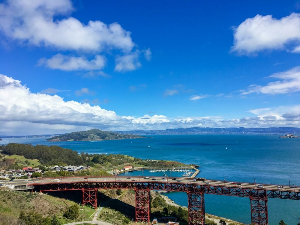
The Marin Headlands are the hills on the Marin side of the Golden Gate, part of the Golden Gate National Recreation Area. For more than a century the Army fortified them to guard the entrance to San Francisco Bay, and most of that left-behind military ground is now open to walk. This is a day trip for people visiting and people who live here. It sits alongside the other trips on the Day Trips hub and the car-free day trips guide. Facts below were read from official pages on November 3, 2026; anything we could not confirm is labelled.
A Day Plan
- Morning: walk the Golden Gate Bridge. Cross on the east sidewalk, take in the views from the Marin side, then decide whether to walk back or carry on. See the bridge section below.
- Midday: the gun batteries. Pick one: the short Batteries Loop, or the Coastal Trail up to Battery Townsley from Rodeo Beach.
- Afternoon: Rodeo Beach or Tennessee Valley. Rodeo Beach sits at Fort Cronkhite next to the lagoon. Tennessee Valley is a flat walk to a cove.
- If the calendar lines up: the Nike missile site and the Battery Townsley interior are open only on set days each month (see the military sections).
Not confirmed: We have not tested this order on the ground, and we have not verified a walking route from the bridge to the batteries. Treat it as a way to sequence the stops, and check the NPS map for how they connect.
Getting There
- By car: the NPS says trails can be reached from Highway 101 at the Rodeo Avenue exit (Rodeo Beach trailhead) and at the Spencer Avenue exit (Morning Sun trailhead).
- By bus: the NPS Marin Headlands map notes that San Francisco Muni line 76X, the Marin Headlands Express, serves major sites in the Headlands on Saturdays, Sundays and most holidays.
- Cell service: the NPS warns you may lose it in parts of the Headlands, so download your map first.
- Do not use Wolfback Ridge Road: the NPS says access from it is prohibited because the road is private.
Not confirmed: The current 76X timetable and stops. The sources we found for it were old, so check the SFMTA site before you plan around it. Also not confirmed: parking details at each trailhead.
Walking Across the Golden Gate Bridge
The Golden Gate Bridge District says pedestrians, including people in wheelchairs, may use only the east sidewalk, the side that faces San Francisco. Its figures for the bridge: 8,981 feet abutment to abutment including approaches (about 1.7 miles), a 4,200-foot main span, towers 746 feet above the water, built 1933 to 1937. Our own arithmetic: there and back is about 3.4 miles.
| Item | What the agency says |
|---|---|
| Sidewalk for walkers | East sidewalk only |
| Summer hours (Pacific Daylight Time, early March to early November) | 5:00 am to 9:00 pm; gates close and reopen automatically |
| Winter hours (Pacific Standard Time, early November to early March) | 5:00 am to 6:30 pm; gates close and reopen automatically |
| Not allowed on the sidewalks | Electric scooters, roller blades, skateboards and roller skates, pushcarts, drones; non-service animals being led, ridden or driven |
| Early closures | Some weeknights the east sidewalk closes an hour early during construction; in summer a sidewalk may close at 8 pm |
| South end parking (southeast visitor lot) | $5 an hour, 3-hour maximum, 37 spaces, open 7 am to 9 pm; the district shows a weekend and holiday closure alert for 5/25 to 10/12/2026 |
| North-east lot | Free, 4-hour limit, restrooms |
Not confirmed: The district says the winter switch happens in early November and the dates vary. Today is November 3, so the closing time may already be 6:30 pm. Check the district page for the date it changed.
Not confirmed: Which Muni and Golden Gate Transit routes reach the bridge. The district page sends you to its public transit page without listing them here.
Golden Gate Bridge District: bikes and pedestrians
Golden Gate Bridge District: directions and parking
Golden Gate Bridge District: design and construction facts
For the bridge itself, see the Golden Gate Bridge visitor guide and bridge history.
The Military Coast: Forts, Batteries and a Missile Site
The Headlands hold the remains of three layers of defence. Early batteries from the late 1800s and early 1900s were built around the entrance to the bay. World War II added the huge 16-inch guns. The Cold War added a missile site. The NPS groups them into two old posts: Fort Barry, which holds the Nike Missile Site, and Fort Cronkhite, which holds Rodeo Beach, Rodeo Lagoon and Battery Townsley.
Battery Townsley
| Item | What the agency says |
|---|---|
| Completed | 1940; the War Department approved two batteries in 1928 |
| Guns | Two 16-inch guns, each firing a 2,100-pound shell |
| Range | 25 miles out to sea, about the distance to the Farallon Islands |
| Secrecy | Civilians knew batteries existed in the Headlands but not their exact places |
| In wartime | Over a hundred soldiers lived inside, ready to fire on five minutes’ warning; each gun was fired nearly 100 times, only in practice |
| How to reach it | Coastal Trail from the Rodeo Beach trailhead, 0.7 miles; the NPS calls the walk strenuous and says to allow at least 45 minutes from the lot |
Rangers and volunteers give tours of the inside on open days. The Parks Conservancy lists the battery as open on the first Sunday of each month, noon to 4 pm. The NPS page directs visitors to its park calendar to confirm the next open house.
Not confirmed: Open-house dates. We worked out that the next first Sunday is December 6, 2026, but neither agency says so. Confirm on the NPS calendar. Whether dogs are allowed at the battery is not stated on the NPS page.
The Batteries Loop
| Item | What the agency says |
|---|---|
| Distance | 0.5 mile, about an hour, 60 feet of climbing |
| Starts at | Battery Alexander parking area; either direction works |
| Batteries on the loop | Smith-Guthrie, O’Rorke and Alexander |
| Surface | Compacted natural material; a former jeep road between the batteries, since narrowed |
| Dogs | Leashed dogs permitted |
| Views | Pacific Ocean, surf at Rodeo Beach and, on clear days, the Farallones about 30 miles away |
| Water | None on the trail; a vault toilet at the parking area |
The NPS warns that bluff cliffs can be unstable, so heed the railings and signs, and watch for poison oak.
Other Batteries
Battery Spencer, Battery Wallace, Battery Mendell and Battery Rathbone are also part of the Headlands defences. The NPS lists Battery Spencer and Hawk Hill among the scenic vistas, and says Battery Wallace has a picnic area near the Point Bonita trailhead with tables and grills but no water.
Not confirmed: Dates and guns for Spencer, Wallace, Mendell and Rathbone. Search summaries gave Battery Spencer as completed 1897 with three 12-inch guns and Battery Wallace as 1922 with two 12-inch guns, but Wallace is dated 1917 elsewhere and Mendell is dated 1901, 1902 or 1905. We have not read an NPS page for these four, so we are not printing dates. Also not confirmed: parking at Battery Spencer.
Nike Missile Site SF-88
SF-88 is a restored Nike missile site at Fort Barry, preserved as it was when it operated. The NPS says the U.S. Army built and ran close to 300 Nike sites across the country from 1953 to 1979, meant as a last line of defence against Soviet bombers that got past Air Force interceptors.
| Item | What the agency says |
|---|---|
| Open | First Saturday of each month, 12:00 to 3:00 pm; closed in bad weather |
| Reach it by | Field Road |
| Restrooms | Portable toilets only at the site; a larger rest stop with running water is about a mile before it on Field Road |
| Questions | Park phone 415-561-4700 or GOGA_MarinHeadlands_Info@nps.gov |
Not confirmed: Hours differ by source. One search summary of an NPS page gave Saturdays, 12:30 to 3:30 pm. The page we read says the first Saturday only. Check the calendar before driving out. Admission price and tour times are not on the page.
Point Bonita Lighthouse
Point Bonita Lighthouse is inside Fort Barry. A search summary of the NPS page says the suspension bridge to the lighthouse is closed until further notice, though a viewing platform can be reached during open hours, and that the Point Bonita trail is open the third Saturday of the month. Read the NPS page for the current rules before you go.
Not confirmed: Whether the bridge has reopened, and the trail days. We saw them only in a search summary, not on the NPS page itself.
Hiking
Hikes in the Headlands, with distances, are in the Hiking Near San Francisco guide. Short version: the Batteries Loop is half a mile, Battery Townsley is 0.7 miles from Rodeo Beach, and the Tennessee Valley trail to the beach is 1.75 miles. Dogs are welcome on many Headlands trails but not on the Tennessee Valley trail.
What to Bring
- Water and food. The NPS says there is no water on the Batteries Loop or at the Battery Wallace picnic area, and food vendors are limited.
- Layers. The NPS says coastal weather can change quickly.
- An offline map, since cell service drops out.
- Long trousers where you can, because of poison oak, which the NPS flags on its trail pages.
What We Could Not Confirm
- The current Muni 76X timetable and stops.
- Parking at Battery Spencer, Rodeo Beach and Morning Sun.
- Open dates for Battery Townsley and the Nike site, which differ by source.
- Whether Point Bonita Lighthouse bridge has reopened.
- A walking route from the bridge to the batteries.
- Dates and guns for Batteries Spencer, Wallace, Mendell and Rathbone.
Plan Around the Trip
More Guides
Point Reyes Day Trip From San Francisco: Elephant Seals and Fees
Point Reyes National Seashore is free to enter and open every day. When to see elephant seals, how to get to Chimney…
Read the guide →Hiking Near San Francisco: Lands End, Marin Headlands and the Bridge
Trail lengths, surfaces and dog rules for Lands End and the Marin Headlands (Batteries Loop, Battery Townsley, Tennessee Valley), from NPS and…
Read the guide →San Francisco Wildflowers and Plants: Where and When to See Them
Native coastal scrub and dune plants, California poppies, lupine, redwoods, and the Botanical Garden and Conservatory of Flowers in San Francisco, from…
Read the guide →Questions People Ask About Marin Headlands Day Trip: Golden Gate Bridge Walk, Hikes and Gun Batteries
Can you walk across the Golden Gate Bridge?
Yes. Pedestrians use the east sidewalk only. The Bridge District lists summer hours of 5 am to 9 pm and winter hours of 5 am to 6:30 pm. The bridge is about 1.7 miles long, so there and back is about 3.4 miles.
What military sites can you see in the Marin Headlands?
Battery Townsley (two 16-inch guns, completed 1940), the Batteries Loop (Smith-Guthrie, O'Rorke and Alexander) and the Nike Missile Site SF-88, which the NPS opens on the first Saturday of each month from 12 to 3 pm.
Can I get to the Marin Headlands without a car?
The NPS map notes Muni line 76X serves major Headlands sites on Saturdays, Sundays and most holidays. We could not confirm the current timetable, so check the SFMTA site.
Is there food in the Marin Headlands?
The NPS says there are limited food vendors, so bring your own food and water. You may also lose cell service in parts of the Headlands.
More to Explore
Happening Soon
- Treasures of the Pharaohs Sat, Aug 1, 2026 – Jan 31, 2027 · de Young Museum
- Ferry Plaza Farmers Market Sat, Sep 12 – Dec 31 · Ferry Building Plaza
- Heart of the City Farmers Market Sun, Sep 13 – Dec 31 · Fulton Plaza, Civic Center
- SF State Observatory Public Nights (Wed–Fri, through Dec 4) Thu, Oct 1 – Dec 4 · SF State Observatory, Thornton Hall
Places to Check Out
- Alta Plaza Park Parks & Playgrounds
- Angelo J. Rossi Playground Parks & Playgrounds
- Aquarium of the Bay Attractions
- Asian Art Museum Museums
Cite this page: Project SF, “Marin Headlands Day Trip: Golden Gate Bridge Walk, Hikes and Gun Batteries”, projectsf.com/guides/marin-headlands-day-trip/ (updated ).